

Short answer: Manaslu in Nepal is the eighth highest mountain in the world at 8,163 m, standing north of Pokhara on the western edge of the Annapurna massif, close to the Tibetan border. There is no airstrip and no road to its foot, so you reach the mountain on foot from the trailhead at Machha Khola, 870 m, walking up the Budhi Gandaki gorge, or you fly to one of the helipads that serve the circuit at Samdo, 3,860 m, and above Bimthang on the far side of the Larkya La, 5,160 m. No helicopter lands at base camp and none lands on the summit. The published way to see it with a flight attached is the 13-day Manaslu Helicopter Return Trek at $2,160 per person on a shared flight.
- 8,163 mManaslu, the eighth highest mountain in the world
- 5,160 mLarkya La, the high point reached on foot on the circuit
- 3,860 mSamdo, the highest Manaslu helicopter pick-up we publish
- $2,160Per person, shared flight, 13-day Manaslu Helicopter Return Trek
Manaslu in Nepal is one of those mountains that people can name but cannot place. It is not on the Everest road, it is not the peak that fills the window on a Kathmandu mountain flight, and there is no day tour to it. What it does have is a complete circuit around the massif, a restricted-area permission that keeps the trail quiet, and a helicopter pick-up at the top of the circuit that removes the long walk back to the road.
This guide answers the location question first, then the place names and altitudes, then the booking question, because most of the confusion about this mountain comes from mixing those three up. Everything below uses the numbers we publish on our own itineraries and the figures on the mountain's public record. Where another operator quotes something that disagrees with them, ask which year the number was set.
Where Manaslu in Nepal actually stands
Manaslu rises to 8,163 m, which makes it the eighth highest mountain in the world. It sits north of Pokhara, on the western edge of the Annapurna massif, close enough to the Tibetan border that the villages on its northern flank are culturally Tibetan rather than middle-hills Nepali. The mountain stands inside the Manaslu Conservation Area, a protected basin drained by the Budhi Gandaki river, and it is that river, not a road, that decides how anybody gets close to it.
The headline altitude is the figure to check against any brochure, and the Manaslu entry on Wikipedia is a sensible cross-reference for it. What matters more for a traveller is that the mountain is not one shape. It is a long ridge with three distinct faces, and each face is seen from a different point on the circuit.
The east face rises directly above Sama Gaun, the largest village on the upper route. The south face stands above the glacier where base camp sits. From the Larkya La you are looking at the north-eastern shoulder rather than the summit itself. Three photographs of the same mountain taken on a single trek can look like three different peaks, which is why a good itinerary describes viewpoints rather than just naming the mountain.
That geography explains the cultural split too. Below Namrung the trail is Hindu and Buddhist middle hills, with terraced fields and zinc roofs. Above it, the villages are Tibetan in language, architecture and religion, and the mani walls and gompas start to look like the far side of the border, because culturally they are.
How far Manaslu is from Kathmandu, and why the road stops where it does
There is no airstrip anywhere in the Manaslu region, which is the single fact that shapes every trip here. The circuit starts in Kathmandu because that is where the restricted-area permission is arranged and that is where the road begins. From Kathmandu the drive runs west to Pokhara and then on to the mouth of the Budhi Gandaki valley, where the walking starts at Machha Khola, 870 m. Tarmac gives way to dirt, the dirt gives way to a footpath, and then the gorge closes in.
The first days on the trail are subtropical: river valley, terraces, long suspension bridges, villages at Jagat, 1,340 m, and Deng, 1,860 m. Above Deng the valley changes character twice, once at Namrung, 2,630 m, where the architecture and the prayer flags turn Tibetan, and again above Shyala, 3,575 m, where the last trees go and the trail climbs into open pasture. Sama Gaun at 3,530 m is the hinge of the whole route, the place where groups take a rest day and where the base camp walk begins.
| Place on the route | Altitude | What happens here |
|---|---|---|
| Machha Khola | 870 m | Road head and first night on the trail, at the mouth of the Budhi Gandaki |
| Jagat | 1,340 m | First full day of walking, subtropical river valley |
| Deng | 1,860 m | Rocky ridge into the narrow part of the gorge |
| Namrung | 2,630 m | The villages turn Tibetan in language and architecture |
| Shyala | 3,575 m | Last trees, valley opens toward the east face |
| Sama Gaun | 3,530 m | Main upper village, rest day and the base camp walk |
| Samdo | 3,860 m | Highest village on the circuit and a helicopter pick-up point |
| Dharamsala | 4,460 m | Pass base, a short night before the crossing |
| Larkya La | 5,160 m | The pass, the high point of the trek on foot |
| Bimthang side | 3,590 m | West of the pass, where the walk rejoins the road network |
Read that ladder and the shape of the problem is obvious. There is no single big climb, there are several days of small ones, and the body has to be given time to accept each step. It is also why the helicopter exit matters so much. The walk out from the pass to the road takes most groups three to four more days of descent on tired legs, and the flight removes that stretch from the itinerary entirely.
Three faces, three viewpoints, and the only one you reach on foot
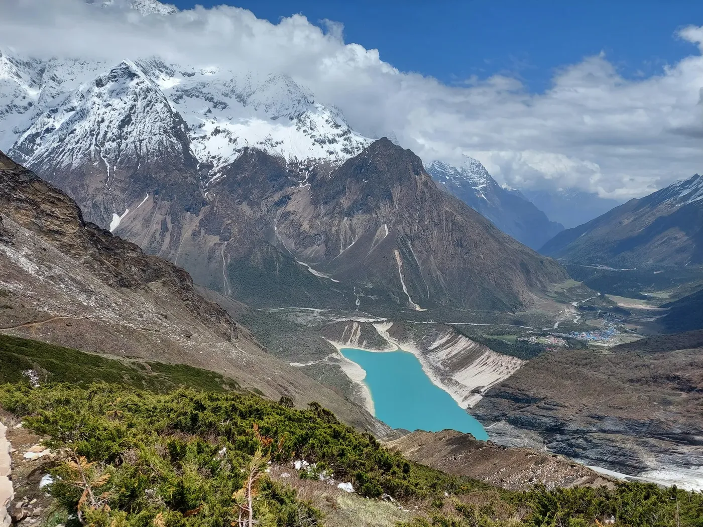
The village viewpoint is Sama Gaun. The mountain's east face fills the sky above the roofs, and the rest day on the itinerary exists partly so that you can walk up toward the glacier at a slow pace and look at it properly. The base camp walk starts and ends at 3,530 m, climbs through yak pasture and moraine onto the ice, and fills a day at walking pace. What waits at the top is a working expedition camp: tents pitched on the glacier, gear stacked and covered, fixed ropes running up the slope, and no shelter of any kind for a visitor. Our guide to Manaslu Base Camp covers that day in detail, including why the camp is not a landing site.
The pass viewpoint is the Larkya La at 5,160 m, and it is the highest ground a trekker stands on. From the pass you are not looking at the summit; you are looking at the north-eastern shoulder, with the Annapurna and Manaslu ranges stacked behind it. Prayer flags, a chorten, and a great deal of wind are what you find up there. The Manaslu summit guide deals with the peak itself and with the reasons no rotorcraft settles on an 8,000 m ridge.
The third viewpoint is the air. Aircraft approach the valley from the south, along the Budhi Gandaki, not over the summit ridge, so a passenger sees the gorge open out and the wall of the massif assemble ahead of the aircraft rather than below it. That is the closest a helicopter gets, and it is close enough that the mountain stops being scenery and becomes a wall.
Where a helicopter can land in the Manaslu region
The landing points we publish on this circuit are at Samdo, 3,860 m, and on the far side of the pass above Bimthang, the village at 3,590 m where the walking rejoins the road network on the Dharpani side. Both were chosen for the same reasons a pilot chooses any site in Nepal: open ground, a clean departure line, room to set down without the tail rotor near a wall, and an altitude the aircraft can still climb out of with a load on board.
Neither base camp nor the summit is a landing site. Base camp sits on broken glacier ice with crevasses and expedition traffic, and the summit is 8,163 m of ridge in the death zone. The highest landing we publish anywhere in Nepal is Kala Patthar at 5,545 m on the Everest Base Camp day tour, and that is a ridge beside base camp rather than the summit of anything. Aircraft reach high places and they land in low ones, and that one sentence answers most of the questions people ask about helicopters and big mountains. The full list of sites, from Lukla at 2,845 m upward, is in our guide to where a helicopter can land in Nepal.
What that means in practice is that a helicopter does not shorten the trek to the mountain, it shortens the exit from it. You still walk the gorge, still sleep in the villages, still cross the pass on foot. What you buy is the descent, replaced by a single flight from the Dharpani side instead of three to four days of walking.
What seeing Manaslu in Nepal costs in 2026
Prices for this mountain are quoted per person on a shared flight, in US dollars, and the format decides the number far more than the season does. A 13-day trek up and fly out costs $2,160 per person on a shared flight, with the helicopter exit included. Walking the circuit both ways instead removes the flight but adds the days, and the permits alone run to about US$250 per person on a two-week autumn trek, before lodging and food for the extra walking days.
| Format | Days | Published price | High point |
|---|---|---|---|
| Manaslu Helicopter Return Trek, trek up and fly out | 13 | $2,160 per person, shared flight | Larkya La, 5,160 m on foot |
| Manaslu Circuit walked both ways | 14 to 16 | Permits about US$250 per person, plus lodging and food | Larkya La, 5,160 m on foot |
| Everest Base Camp Helicopter Trek, for comparison | 10 | $1,840 per person, shared flight | 5,545 m at Kala Patthar |
The comparison row is there for a reason. Manaslu is not the cheap version of an Everest trip and it is not the expensive version of one either; it is a different product, priced by days and by the fact that a restricted-area permit sits underneath it. Anyone shopping on price alone will end up comparing a 13-day restricted-area trek with a 10-day Khumbu itinerary and concluding the wrong thing about value.
What the price does not vary with is honesty about the exit. Some quotes advertise a Manaslu helicopter trek and then land at a village that still leaves two days of walking to the road. Ask which helipad, at what altitude, and on which side of the pass, and the quote becomes comparable. Our Manaslu Helicopter Return Trek page sets out the day-by-day route and the price in full.
Booking Manaslu from the United States: dollars, seasons and paperwork
Three things get decided before you leave home: the season, the format and the paperwork. The season is the easiest. October and November are the clearest months of the year here, the monsoon has washed the haze out of the air, and the mountain is at its most photographed. March to April is the second window, warmer and greener, with a shorter clear period each morning as the valley heat builds. The monsoon, roughly June to mid-September, grounds flights and closes trails, and December to February is clear but genuinely cold at altitude.
The format is the second decision, and it comes down to how much walking you want against how much time you have. Thirteen days is the published trek-up, fly-back format. Fourteen to sixteen days is the circuit walked both ways. There is no third option where a helicopter delivers you to the mountain and back in a morning, because the mountain is eight days of trail from the nearest road and the aircraft cannot land at either end of that walk.
The paperwork is where bookings actually fail. The restricted-area permission for Manaslu is arranged in Kathmandu before departure and cannot be fixed at the trailhead. That is the difference between this trip and an Everest day tour you can book at short notice. Our planning guide suggests about a week of lead time for a helicopter booking in general; a restricted-area trek deserves more, and the sensible sequence is permission confirmed in writing, then international flights, then everything else.
Paying from abroad is straightforward because the published prices are in US dollars per person on shared flights. What catches people out is the calendar rather than the currency: a trip booked for the last week of October is booking into the single busiest week of the Nepali trekking year, and the lodges on the upper circuit fill before the aircraft do. Book the season you want, not the one that is left.
The seasons that work, and the ones that do not
Autumn runs from late September to November and peaks in October. The monsoon retreats, the air clears, and the high passes are usually open until the first heavy snow. Spring runs from March to May and is the second-best window, with rhododendron lower down and longer days, though cloud builds earlier in the afternoon as the season advances. Both windows share one rule: fly and walk early, because the mountain makes its own weather by mid-morning.
Winter is not closed, but the pass is the constraint rather than the aircraft. December to February brings clear skies and hard cold, and the Larkya La at 5,160 m can be a serious proposition with wind and snow. The monsoon is the season to avoid: low cloud, rain and poor visibility ground most flights for weeks at a time, and the trail is leech-ridden, slippery and frequently cut. The month-by-month detail is in our guide to the best time for a helicopter tour in Nepal, and it applies to this valley as much as to the Khumbu.
What Manaslu in Nepal is not
Four corrections save people a lot of money and disappointment.
- It is not a day tour from Kathmandu. The nearest road head is at 870 m, the mountain is eight days of trail beyond it, and no aircraft lands at either base camp or the summit.
- It is not a summit trip for trekkers. 8,163 m is climbed by expedition over weeks, with fixed ropes and bottled oxygen; the trekker's high point is the Larkya La at 5,160 m.
- It is not a loop you can walk in either direction on a whim. The circuit runs one way, and the exit side decides whether the helicopter meets you at Samdo or above Bimthang.
- It is not a quiet version of Everest with the same infrastructure. There are no cash machines, no hospitals and no road, and the restricted-area system exists precisely to keep the numbers down.
Every one of those points argues for the same conclusion: this is a trip you plan, not a trip you improvise. The Nepal beyond Everest guide shows how Manaslu sits alongside Langtang, Gosaikunda and Rara, and why it is the most demanding of the quiet destinations we fly.
For travellers already in Nepal or coming in from India
The permission system does not care where you are from. Nepali and Indian passport holders walk the same restricted-area route, carry the same Manaslu Conservation Area entry and the same restricted-area permission, and face the same 13-day calendar, so a local booking is not a shorter booking. What does change is the road leg: the trailhead is reached from the Pokhara side, so travellers already in Pokhara can join there instead of making the drive from Kathmandu first.
The helicopter pick-up at Samdo is a domestic operation, flown from Kathmandu or Pokhara by a Nepali operator, and it is the same aircraft whether the passengers booked from Kathmandu, Pokhara, Delhi or Denver. That is worth knowing when a reseller quotes a price that looks too good: what you are buying is a seat on a flight that departs from a Nepali helipad on a fixed morning, and the seat does not get cheaper because it was sold abroad.
Frequently asked questions
Where exactly is Manaslu in Nepal?
North of Pokhara, on the western edge of the Annapurna massif and close to the Tibetan border, inside the Manaslu Conservation Area. It is the eighth highest mountain in the world at 8,163 m, and the Budhi Gandaki river drains the valleys around it.
How far is Manaslu from Kathmandu?
There is no road or airstrip at the mountain. The drive from Kathmandu runs west to Pokhara and on to the trailhead at Machha Khola, 870 m, and from there the circuit takes several days of walking to reach the upper villages, with Sama Gaun at 3,530 m and Samdo at 3,860 m.
Can a helicopter land on Manaslu?
No. The summit is 8,163 m of ridge in the death zone, with no flat ground and no way for an aircraft to set down or climb out safely. Every Manaslu flight we sell lands in the valleys below, at Samdo, 3,860 m, or above Bimthang on the Dharpani side.
Where does a helicopter land in the Manaslu region?
The published pick-up points are the helipad at Samdo, 3,860 m, at the top of the circuit, and the landing area above Bimthang, 3,590 m, on the far side of the Larkya La. Both are open, level and chosen for the departure line a pilot needs.
Can you reach Manaslu base camp by helicopter?
No. Base camp sits on the glacier below the south face, on broken ice with crevasses and expedition traffic, and no helicopter lands there. The aircraft that serve the valley use Samdo or the Bimthang side instead, and the base camp walk is made on foot from Sama Gaun.
Do you need a permit to visit Manaslu in Nepal?
Yes. The circuit sits inside the Manaslu Conservation Area and requires a restricted-area permission, which is arranged in Kathmandu before departure. Permits alone run to about US$250 per person on a two-week autumn trek.
Is there an airstrip near Manaslu?
No. That is the main difference between this mountain and the Everest region, where Lukla has an airport at 2,845 m. Manaslu is a road-and-trail route, and the helicopter is the only flying option on the circuit.
What is the best month to see Manaslu?
October. The monsoon has cleared the air, the passes are usually open and the mountain is at its most visible. November is nearly as good, and March to April is the second window, with clearer mornings and more cloud by afternoon.
How many days does it take to see Manaslu?
Thirteen days on the published trek-up, fly-back format, or fourteen to sixteen days if you walk the circuit both ways. The walking days do not change with the flight; what changes is the three to four day descent at the end.
How much does the Manaslu helicopter trek cost?
$2,160 per person on a shared flight for the 13-day Manaslu Helicopter Return Trek, with the helicopter exit included. That is the 2026 published price, and it is per person rather than per aircraft.
Do I need to be a climber to see Manaslu?
No. The circuit is a trek, not a climb, and the high point on foot is the Larkya La at 5,160 m. Fitness and acclimatisation matter far more than technical skill, and the helicopter exit removes the part of the route most people find hardest on the body.
Can I book the Manaslu trek from the US?
Yes, and it is the normal way it is booked. Prices are published in US dollars per person on shared flights, the permission is arranged in Kathmandu on your behalf, and the practical advice is to confirm the permission before paying for international flights.
Manaslu rewards the traveller who treats it as a route rather than a photo stop. The mountain is 8,163 m of ridge and glacier, the trail to it is a week of villages and gorge, and the flight out is the one modern shortcut the valley allows. Everything else, including the pass at 5,160 m, is still on foot.
If you want the mountain with the walk included and the descent removed, the 13-day Manaslu Helicopter Return Trek is the published format and the one we fly most often. Send us your dates and we will tell you honestly whether the season, the pass and your calendar line up, because on this mountain the weather decides more of the trip than the brochure does.